Understanding Real Estate Aerial Photography
What is Aerial Photography?
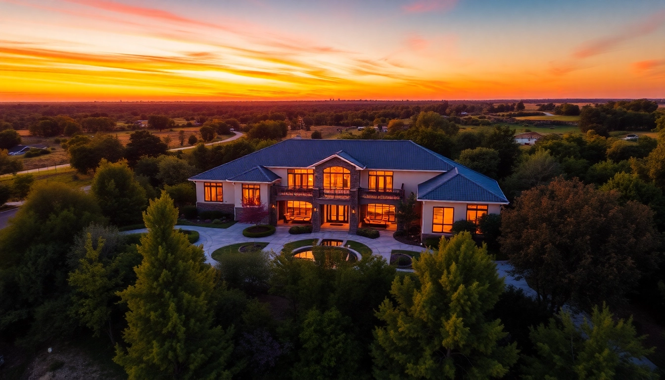
Aerial photography involves taking photographs of the ground from an elevated position, typically using drones, helicopters, or fixed-wing aircraft. This practice offers a perspective that is often unattainable with traditional ground-based photography, allowing for comprehensive views of properties and their surroundings. The unique angle highlights property features, landscapes, and neighborhood layouts, making it an invaluable asset in various fields, notably in real estate.
Benefits of Aerial Photography for Real Estate
The integration of real estate aerial photography into listings provides numerous advantages:
- Enhanced property visualization: Buyers can gain a clearer understanding of the property layout and surrounding amenities.
- Highlighting unique features: Aerial shots can emphasize elements like swimming pools, gardens, and proximity to schools or parks.
- Increased engagement: Listings with aerial photography typically attract more views and longer engagement times, boosting the likelihood of a sale.
- Competitive edge: Utilizing aerial photography sets a real estate agent or firm apart from competitors who might only use traditional photography.
Technologies Used in Aerial Photography
Aerial photography has evolved significantly with advancements in technology. Modern techniques include:
- Drones: Drones are the most popular tools for aerial photography due to their affordability, maneuverability, and accessibility. Equipped with high-resolution cameras, they can capture stunning images from various altitudes.
- Helicopters and airplanes: For larger properties or expansive landscapes, helicopters and fixed-wing aircraft can provide broader views.
- Software: Post-processing software, such as Adobe Photoshop and Lightroom, helps refine images, ensuring they are as striking as possible before they are used in marketing.
- 3D Mapping Technology: These technologies allow for creating detailed 3D models of properties, providing potential buyers with immersive visuals.
Best Practices for Capturing Stunning Aerial Shots
Choosing the Right Equipment
When setting out to capture compelling aerial photographs, selecting the appropriate equipment is crucial. Key considerations include:
- Camera quality: A camera with a high-resolution sensor (at least 20 megapixels) is recommended. Look for features like optical zoom and RAW image capabilities for better post-processing.
- Drone specifications: Ensure the drone has a stable flight capability, good battery life, and GPS for accurate photography.
- Gimbal systems: Employing a gimbal stabilizes the camera during flight, yielding smoother images and video.
Optimal Timing and Lighting Conditions
When it comes to aerial photography, timing and lighting are paramount:
- Golden hour: Shooting during the golden hour, shortly after sunrise or before sunset, offers the best lighting conditions. The soft, warm light enhances property features and minimizes harsh shadows.
- Weather considerations: Ideal weather conditions (clear skies, low wind) are critical for steady shots; avoid shooting on overcast or rainy days.
Framing and Composition Techniques
Effective composition can transform an ordinary image into an extraordinary one. Some key techniques include:
- Rule of thirds: Position key elements along the horizontal and vertical grid lines to create balance in your photos.
- Leading lines: Utilize natural lines in the landscape (like roads or fences) to lead the viewer’s eye towards the property.
- Variety of angles: Capture images from multiple angles and heights; this gives potential buyers an all-encompassing view of the property.
Integrating Aerial Photography into Real Estate Marketing
Creating Compelling Visual Listings
Incorporating aerial photography into listings enhances their appeal:
- Highlighting properties: Use aerial images to showcase the property’s size and unique features, especially for large estates or multi-family units.
- Combining formats: Pair aerial photographs with detailed descriptions to paint a comprehensive picture of the property.
Utilizing Social Media for Exposure
Social media platforms can significantly expand the reach of aerial photographs:
- Visual platforms: Share aerial shots on visually driven platforms like Instagram and Pinterest, where stunning images can quickly go viral.
- Targeted ads: Use Facebook and Instagram ads featuring aerial images to target potential buyers based on demographics and interests.
Case Studies of Successful Aerial Marketing
To illustrate the impact of aerial photography in real estate, consider the following case studies:
- Case Study 1: A real estate agency used drone photography for a luxury property and saw a 30% increase in inquiries within a week of the listing going live.
- Case Study 2: A commercial property listed with soaring aerial views not only drew unprecedented attention but also sold above asking price, illustrating the value of presentations that exploit unique perspectives.
Common Challenges in Real Estate Aerial Photography
Weather and Environmental Considerations
Aerial photography is significantly affected by weather conditions:
- Wind: High winds can destabilize drones, leading to shaky images or even crashes.
- Rain and storms: These can damage equipment and compromise the quality of images.
Legal Regulations and Permissions
Before taking aerial photographs, understanding local laws and obtaining necessary permissions is essential:
- FAA regulations: In the United States, all drone operators must follow Federal Aviation Administration (FAA) regulations, particularly around flight heights and proximity to airports.
- Property permissions: Always secure permission from property owners before taking aerial photographs to avoid trespassing issues.
Post-Production Challenges
After capturing aerial images, several post-production challenges may arise:
- Editing proficiency: Proficient use of editing software is critical to enhance photos without compromising their authenticity.
- Time investment: Effective post-production can be time-consuming; it’s essential to allocate adequate resources.
Measuring Success and ROI from Aerial Photography
Key Performance Indicators to Track
Evaluating the effectiveness of aerial photography is vital in understanding its impact on sales:
- Inquiries and leads: Track how many inquiries a listing receives after incorporating aerial photography.
- Engagement metrics: Assess engagement levels on social media posts and listings to gauge viewer interest.
Feedback and Customer Engagement Metrics
Collecting feedback can provide insights into how aerial photography is perceived:
- Surveys: Conduct surveys among clients to gather impressions about the aerial images used in listings.
- Engagement analysis: Monitor metrics such as click-through rates and time spent on listings to evaluate engagement levels.
Adjusting Strategies Based on Results
Adapting strategies based on performance metrics is crucial:
- Testing variations: Experiment with different styles of aerial photography (e.g., sunrise versus sunset shots) to determine which elicits higher engagement.
- Refining approaches: Use customer feedback to hone in on elements that resonate most with buyers, refining your aerial photography strategy accordingly.